
Hyderabad’s battle with floods is far from over. Twenty-five years after the devastating deluge of August 2000, the city continues to remain vulnerable to heavy rains and flash floods. Despite detailed flood maps, stormwater studies, and multiple warning reports, little has changed on the ground. Encroachments, poor drainage systems, and unchecked urbanisation keep the city on edge, with every monsoon reviving fears of disaster.
A City Repeating History
The August 2000 floods were Hyderabad’s worst in decades, with more than 90 colonies submerged and thousands displaced. Heavy downpours on August 23 and 24 inundated working-class neighbourhoods near Hussainsagar, leaving over 20 dead and losses pegged at ₹700 crore. At that time, authorities promised such devastation would never recur. The Geological Survey of India (GSI) and Kirloskar Consultants mapped flood-prone zones and designed a stormwater drainage master plan. Yet, implementation stalled due to political pressure and encroachments.
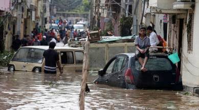
This year on August 7, Hyderabad once again went underwater when Picket Nala overflowed into Viman Nagar and Ameerpet, halting economic activity. For residents like Sonu Singh of Chikkadpally, who also witnessed the 2000 floods, the experience felt like déjà vu. “We are used to it since childhood,” he remarked, resigned to recurring inundation.

Experts say the city’s drainage system has been crippled by unchecked construction along nalas and lakes. The Comptroller and Auditor General (CAG) report of 2017 revealed that the Greater Hyderabad Municipal Corporation (GHMC) completed improvement works on only 24 out of 71 identified stormwater drains. Even these were incomplete stretches, failing to expand carrying capacity.
Environmentalists argue that political interference is a major barrier. “The Kirloskar report was technically sound, but political pressure and encroachments prevented its execution,” said Donthi Narasimha Reddy of the Save Musi Campaign. Encroachments like Fatima Owais College on the Salkam Cheruvu have only worsened the city’s vulnerabilities.
Rising Rainfall and Climate Challenge
Beyond poor planning, changing rainfall patterns have added to the crisis. Data shows Hyderabad’s average annual rainfall has risen from 768 mm in the 20th century to 918 mm in the last 24 years. The 2020 floods, triggered by 30 cm of rain in 24 hours, killed 33 people—more than in 2000. Losses that year were estimated at ₹679 crore. Even the government’s Strategic Nala Development Programme launched later failed to prevent repeat disasters.
Lessons Still Unlearnt
Hyderabad has a steep north-to-south gradient, which naturally channels water into low-lying areas. Experts as far back as Sir M. Visvesvaraya had recommended building reservoirs to manage floods after the 1908 Musi calamity, which killed over 15,000. The construction of Osmansagar and Himayatsagar was a turning point then. But the 2000 flood, instead of being another wake-up call, was largely forgotten.
Today, residents in Nallakunta, Barkatpura, and Ashok Nagar still live with the same risks. As one car showroom worker in Patny Colony recalled during this year’s floods, “The water reached up to here,” pointing to a wall mark inside the inundated building. Authorities have created the Hyderabad Disaster Management and Asset Protection Agency (HYDRAA) in 2024, but much of the damage comes from decades of neglect.
Not If, But When
The tragedy of Hyderabad’s floods lies not in unpredictability but inevitability. Experts, officials, and residents know which neighbourhoods will drown after every heavy downpour. With rising rainfall, vanishing lakes, and blocked natural channels, the city remains one storm away from disaster. The question is no longer if Hyderabad will flood again, but when—and how badly.