 Safer Travel Through a Sensitive Tiger Habitat
The initiative has been implemented on a 2-kilometre ghat section of an 11.96-kilometre highway corridor passing through the Veerangana Durgavati Tiger Reserve, formerly known as the Nauradehi Wildlife Sanctuary. The area is characterised by dense forest cover, undulating terrain and active wildlife movement, making it a high-risk zone for both motorists and animals.
While the ghat section has been identified as a danger zone due to its geometric conditions, NHAI has ensured that wildlife movement is completely segregated from vehicular traffic through structural and behavioural interventions.
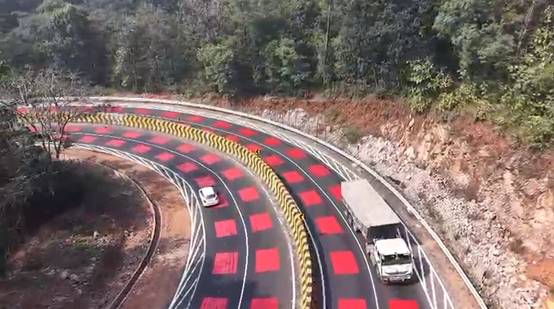
India’s First ‘Table-Top Red Marking’ on a Highway
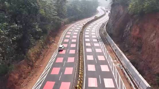
Drawing inspiration from global best practices, including the Sheikh Zayed Road in Dubai, NHAI has introduced India’s first-ever ‘table-top red marking’ on a National Highway. The intervention involves laying a 5 mm thick hot-applied thermoplastic red surface across the carriageway at identified high-risk zones.
The bright red surface serves as an immediate visual warning, alerting drivers that they are entering a speed-restricted, wildlife-sensitive corridor. The slightly raised texture provides mild tactile and audible feedback, naturally encouraging motorists to slow down without sudden braking or discomfort.
Low Ecological Impact, High Safety Gains
What sets this intervention apart is its minimal ecological footprint. The red marking does not disturb wildlife habitats, alter drainage systems or require structural changes to the pavement. Compared to conventional rumble strips, it generates significantly lower noise levels and is easier to maintain.
White shoulder lines have also been added along both sides of the highway to guide drivers and prevent vehicles from drifting into unpaved or grassy areas, further reducing accident risks.
Comprehensive Wildlife Protection Measures
Beyond speed management, NHAI has implemented an integrated wildlife protection system along the entire 11.96-kilometre stretch. A total of 25 dedicated animal underpasses have been constructed at scientifically identified animal movement locations to allow safe crossings.
These underpasses are aligned with natural ground levels and drainage paths to encourage regular animal use. Continuous chain-link fencing, except in deep cutting sections, has been installed on both sides of the highway to guide animals toward these crossings and prevent them from entering the carriageway.
Cameras installed at minor bridges, which also function as animal crossing points, help monitor wildlife movement. Solar-powered lighting at bridges and junctions enhances visibility at potential conflict points without adding to the environmental burden.
A Blueprint for Sustainable Highway Development
By combining international research, scientific planning and on-ground ecological assessment, NHAI has demonstrated that infrastructure growth and conservation goals need not be mutually exclusive. The initiative improves road safety, reduces wildlife-vehicle collisions and preserves forest ecosystems.
As India continues to build highways through diverse and ecologically sensitive landscapes, this project stands as a model for people-centric, wildlife-sensitive and environmentally responsible infrastructure development.