
Sriharikota, July 28, 2025 — India is ready to make history once again. On July 30, ISRO will launch the NISAR Earth Observation Satellite, a joint Indo-US space mission that promises to reshape how the world monitors climate, agriculture, and disasters.
NISAR: A Symbol of Scientific Partnership
Union Minister Dr. Jitendra Singh described the launch as a “scientific handshake with the world.” Developed jointly by ISRO and NASA, the NISAR mission is the first collaboration of its kind between the two space giants.
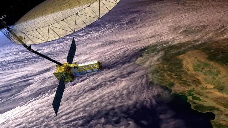
It stands for NASA-ISRO Synthetic Aperture Radar. The satellite combines top-notch technology from both countries. While NASA provided the L-Band radar and high-speed communications systems, ISRO built the S-Band radar, spacecraft bus, and the GSLV-F16 launch vehicle.
Weighing 2,392 kg, NISAR will be placed in a sun-synchronous orbit. It will scan the entire Earth’s surface every 12 days, offering high-resolution, all-weather, day-and-night imaging.


For the first time ever, India’s GSLV rocket will carry a satellite into a sun-synchronous orbit. This marks a technological leap for ISRO and sets the stage for future high-end missions.
The launch is scheduled for 5:40 PM on July 30 from the Satish Dhawan Space Centre in Sriharikota.
Supporting the Vision of ‘Vishwa Bandhu’
Dr. Jitendra Singh emphasized that the mission reflects Prime Minister Narendra Modi’s vision of India as a ‘Vishwa Bandhu’—a global partner dedicated to the good of humanity.
“This is not just a satellite launch. It shows what two democracies committed to science and global welfare can achieve together,” the Minister said during his briefing.
Global Data, Free for All
One of the most remarkable features of NISAR is its open-access policy. All data will be freely available within 1–2 days of capture. In emergency cases, data will be available in near real-time.
This will help not just India and the US, but the entire world—especially countries without advanced satellite systems. Researchers, disaster response teams, and policymakers will benefit immensely.
Tracking Climate, Disasters, and Agriculture
The satellite’s dual radar system uses SweepSAR technology to track changes across the Earth. It can detect even small shifts in land surfaces, offering early warnings for earthquakes, landslides, and volcanic activity.
It will also monitor soil moisture, crop conditions, shoreline changes, storm paths, and sea ice patterns. These insights are crucial for climate resilience, food security, and environmental planning.
“This isn’t just for academic research. Governments will use this data to save lives and shape better policies,” said Dr. Singh.
Ten Years in the Making
The NISAR project began over a decade ago. With a joint investment of more than $1.5 billion, the satellite is a result of years of collaboration, testing, and innovation.
Now, as the launch date nears, anticipation is high. Space agencies, scientists, and governments around the world are watching closely.
Positioning India as a Knowledge Leader
The NISAR launch shows India’s shift from utility-based space missions to global knowledge leadership. It’s no longer just about launching satellites—it’s about sharing insights, solving global problems, and leading with data.
“India is now shaping the global commons with its scientific capability,” Dr. Singh added.
Conclusion: A Launch for the World
As the countdown begins, the NISAR launch stands as a proud moment for both India and the US. It proves what global partnerships can achieve when united by science and shared goals.
It’s more than a satellite. It’s a message. A message of collaboration, hope, and global responsibility.